|
|
|
Advertisements:
EconomyEconomy - overview
Jan Mayen is a volcanic island with no exploitable natural resources, although surrounding waters contain substantial fish stocks and potential untapped petroleum resources. Economic activity is limited to providing services for employees of Norway's radio and meteorological stations on the island.
Comments
Add a new comment: |
Advertisement
Members area
Jan Mayen [ Norway ] (Norway):
 
GPS points from Jan Mayen [ Norway ] (Norway)
|
||||||||

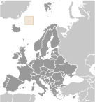 This desolate, arctic, mountainous island was named after a Dutch whaling captain who indisputably discovered it in 1614 (earlier claims are inconclusive). Visited only occasionally by seal hunters and trappers over the following centuries, the island came under Norwegian sovereignty in 1929. The long dormant Beerenberg volcano, the northernmost active volcano on earth, resumed activity in 1970 and the most recent eruption occurred in 1985.